U.S. Forest Service Columbia River Gorge National Scenic AreaOregon Parks and Recreation Department
HOOD RIVER, Ore. (October 2, 2024) — The Historic Columbia River Highway (HCRH) State Trail from Hood River to Mosier will reopen, Thursday, October 3, 2024. This section of the state trail has been closed since late July due to the Microwave Tower Fire. In recent days, carefully planned fire suppression activities successfully put out an old disposal site hotspot that burned close to the trail and emitted noxious smoke into the area.
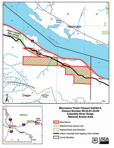
This section of the HCRH state trail between East and West Hatfield Trailheads will open to the public. However, other area closures associated with the Microwave Tower Fire remains in effect on all National Forest System (NFS) lands within the fire perimeter. Public entry to areas outside the trail (U.S. Forest Service closure area) is still prohibited, including entering the disposal site.
“We are excited to reopen the Historic Columbia River Highway State Trail between Hood River and Mosier. Our staff are out there now preparing for reopening, but we still want to warn people that this was a very recently burned area and they should still exercise caution,” said Oregon Parks and Recreation Department Park Manager David Spangler. “We’re very grateful to our partners for all of their diligence and attention to help us reopen this critical recreation and community corridor safely.”
To ensure the safety of local communities and recreationists, firefighters from the Scenic Area and Mosier Fire District worked together to excavate and extinguish hotspots within the burning disposal site. The disposal site is no longer emitting smoke or heat. The Columbia River Gorge National Scenic Area also implemented air monitoring contracts and consulted with Federal and state air quality experts during and after the mitigation work. Recently conducted air monitoring results showed metals with known inhalation health risks were below the limit of detection, and particulate matter levels, which is typical for wildfire smoke, remained low. Low levels of volatile organic compounds associated with the site, along with localized water and soil contamination will remain an ongoing concern, so local, state, and Federal partners continue to collaborate on further hazard mitigation.
“We want to thank our partners and local resources for their commitment to helping extinguish the remaining burning fuels within the disposal site” said Nicolas Granum, Deputy Forest Supervisor for the Columbia River Gorge National Scenic Area. “We ask that visitors do not enter the disposal site and respect the barriers put in place to keep individuals safe while recreating on the nearby trail.”
People intending to hike near the fire area, or any recently burned area, should always remain alert and be aware of increased hazards, particularly snags (which are recently burned or dead trees). Dead or dying trees that remain standing after a fire are unstable, especially in high winds. Loose rocks and logs can be present in a burned area and are unpredictable, creating a falling hazard. Additionally, burned vegetation can also contribute to landslides, mudslides and erosion when rain occurs. The ground in a burned area can also be unstable, due to burned-out roots beneath the surface. After soils and vegetation have been charred, rainfall that would normally be absorbed could run off extremely quickly.
A detailed map and description of the Microwave Tower Fire closure area is available at the end of this News Release, on the Scenic Area website and at the US Forest Service office. Closure barriers and signs have been posted at the location. The HCRH State Trail, managed by Oregon Parks and Recreation Department and Oregon Department of Transportation, may have other advisories in place. For more details, please visit https://stateparks.oregon.gov/.
Additional information about the Columbia River Gorge National Scenic Area is available at https://www.fs.usda.gov/crgnsa.


